Rosà
Charming municipality with a Venetian flair, offering historical architecture alongside modern conveniences, near major cultural hubs, set amid lush plains.
Rosà- Key information
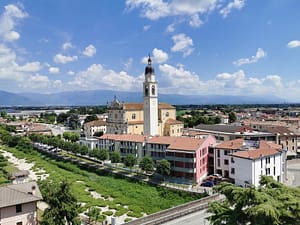
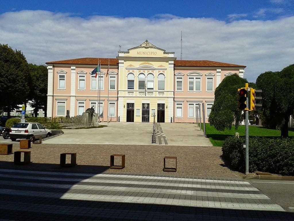
Nestled in the province of Vicenza, Rosà is a charming Italian municipality with a distinct Venetian character. Known locally as Roxà in the Veneto dialect, this town offers a blend of historical architecture and modern amenities, making it an appealing destination for expatriates and tourists alike. Rosà’s strategic position near larger cities such as Vicenza and Venice enhances its attraction, providing easy access to major cultural and economic hubs while maintaining a quieter, laid-back atmosphere. The town is enveloped by lush Venetian plains, which not only enrich its scenic beauty but also support a primarily agricultural economy. Its community is vibrant and welcoming, hosting various cultural events throughout the year that reflect its rich heritage and dynamic social life.
- Quality of Life
4.6
4.6
- Quality of Infrastructure
4
4
- Quality of Economy
3.5
3.5
- Region
Veneto
Veneto
- Elevation
[?]
Elevation of a city refers to the height above sea level at which the city is located, measured in meters.
95
95
- Population
[?]
This is a town's official population, measured each year by the national statistics authority.
14700
14700
- Real Population (5km band)
[?]
Our "Real Population" metric reflects more accurately a town's real size by including inhabitants in the immediate vicinity of the town's official borders.
115500
115500
- Climate Description
Mild winters, warm summers, moderate rainfall and some snow; generally sunny.
- Air Quality Rating
4.1
4.1
- Avg Download Speed (Mbps) / Avg Upload Speed (Mbps)
47 /
19
- Walkability
Very Walkable
- Housing availability
[?]
Based on total number of properties (sale and rent) classifies housing availability into five categories: low, relativel ylow, medium, relatively high and high.
Relatively Low
Rosà Demographics
Population
[?]
This is a town's official population, measured each year by the national statistics authority.
0
Real Population (5km band)
[?]
Our "Real Population" metric reflects more accurately a town's real size by including inhabitants in the immediate vicinity of the town's official borders.
0
Birth to Death Ratio Percentile
[?]
Calculation of the percentile in which the city falls based on the number of births and deaths for year 2023 for the town. In practice, this metric explains how many more deaths than births occur (or vice versa)
Example: Low percentile (near 0): The location has a relatively low birth to death ratio compared to others in Italy. Mid-range percentile (around 0.5): The location has an average birth to death ratio. High percentile (near 1): The location has a relatively high birth to death ratio compared to others.
Example: Low percentile (near 0): The location has a relatively low birth to death ratio compared to others in Italy. Mid-range percentile (around 0.5): The location has an average birth to death ratio. High percentile (near 1): The location has a relatively high birth to death ratio compared to others.
0
Population Data Source
ISTAT,2023
Total Tourists (2023)
[?]
Total number of tourists (foreign and domestic) for years 2005 and 2023 for the city.
0
Touristy Index (2023)
[?]
Calculation of tourist density index for the city, comparing its total tourist number to the overall average tourist number of the region
relative to its own population.The index indicates how a location’s tourist density compares to the average, with values above
100 representing higher-than-average density and values below 100 representing lower-than-average density. In practice, numbers very much higher than 100
0
Income per capita (2023)
[?]
This is an estimation of average income per resident for this town, based on 2023 data from the Italian Ministry of Finance.
0
Income rank in Italy (2023)
[?]
This is a ranking of the town's average income per resident, against the full list of townships in Italy.
2300 out of 7901
Infrastructure and Connectivity
Closest Airport
[?]
Name of the closest airport in the NUTS2 region from the city..
Treviso Airport
Drive time to Airport
[?]
Calculation of the drive time in (mins) to the closest airport the from city.
0
minutes
Distance to Closest Beach Resort
[?]
Calculation of the minimum distance ("as the crow flies") between each city and the closest POI, in this case beach or mountain..
0
km
Distance to Closest Mountain Resort
0
km
Distances to Major Airports
Verona
0
km
Venice
0
km
Treviso
0
km
Bergamo
0
km
Bologna
0
km
Infrastructure & Amenities
POIs 10km 30km
| POI_Type | 10km | 30km |
|---|---|---|
| Auto Repair Shops | 384 | 1.666 |
| Bars | 256 | 1.228 |
| Cafes | 153 | 700 |
| Cinemas | 4 | 40 |
| Dentists | 54 | 234 |
| Golf Courses | 1 | 5 |
| Gyms | 59 | 281 |
| Hiking Trails | 21 | 137 |
| Historical Sites | 33 | 195 |
| Hospitals | 6 | 29 |
| Libraries | 13 | 65 |
| Museums | 26 | 109 |
| Parks | 43 | 157 |
| Pharmacies | 48 | 240 |
| Restaurants | 243 | 1.203 |
| Shopping Centres | 19 | 121 |
| Spas | 218 | 1.164 |
| Supermarkets | 173 | 644 |
Within 10km
Hospitals
0
Auto Repair Shops
0
Bars
0
Cafes
0
Cinemas
0
Dentists
0
Golf Courses
0
Gyms
0
Health Clinics
0
Hiking Trails
0
Historical Sites
0
Libraries
0
Museums
0
Parks
0
Pharmacies
0
Restaurants
0
Shopping Centres
0
Supermarkets
0
Beauty Centres (Spas)
0
Healthcare & Safety
Nearest Hospital Name
San Bassiano-Pronto Soccorso
Drive Time to Nearest Hospital
0
minutes
Number of hospitals within 30-min drive
0
Seismic Zone (risk of earthquakes)
[?]
Official seismic zones classify areas based on earthquake risk.
Moderate Earthquake Risk
Road Accidents Rate per 10k Inhabitants
[?]
Calculation of road accidents per 10,000 people based on the number of deaths and injuries registered in roads for year 2022 for the city.
0
Car Insurance Price Index
[?]
The car insurance price index is a measure of how a city's average car insurance premium compares to the national average,
expressed as a percentage. A value of 100 indicates that the city's premium is equal to the national average.
Values above 100 show higher premiums, while values below 100 show lower premiums.
0
Average Annual Car Insurance Cost
0
Housing & Property Market
Housing availability
[?]
Based on total number of properties (sale and rent) classifies housing availability into five categories: low, relativel ylow, medium, relatively high and high.
Relatively Low
Property Prices per m²
Low (lowest 25%)
0
Median
0
High (highest 25%)
0
Connectivity & Digital Access
Walkability Description
Very Walkable
Avg Download Speed (Mbps)
47
Fast Download Speed (Mbps)
68
Slow Download Speed (Mbps)
21
Education
Avg Schools Ranking (All Criteria)
[?]
This ranking shows in which decile the town's public schools fall while looking at all the indicators provided by the Italian Ministry of Education for the most recent available year. Note that figures are only provided by the ministry at the school catchment area level, and therefore several schools may be grouped together.
Bottom 40%
Avg Schools Ranking (Standardised Tests)
[?]
This ranking shows in which decile the town's public schools fall while looking the students' results in national standardised tests. The data is provided by the Italian Ministry of Education for the most recent available year.
Bottom 30%
Counts of School
| Town/City | Primary Schools | Kindergartens | Comprehensive Schools | Medium High Schools | Scientific High Schools | Technical Commercial Schools | Classical High Schools | Industrial Technical Schools | Higher Education Institutes |
|---|---|---|---|---|---|---|---|---|---|
| Rosà | 4 | 1 | 1 | 1 | N/A | N/A | N/A | N/A | N/A |
Climate & Weather
Precipitation
[?]
Based on daily climate data for precipitation from OPEN-METEO this parameter indicates how a city's annual precipitation compares to others
in terms of percentage, with values ranging from 0 (lowest) to 1 (highest). For example, a percentile rank of 0.75 means the city's
total precipitation is higher than 75% of other cities.
High (71st-80th percentile)
Sunshine
Somewhat Low (21st-30th percentile)
Snowfall
Below Average (31st-40th percentile)
Min Annual Temperature (°C)
[?] This parameter represents the monthly average of daily minimum temperatures for January, based on data from OPEN-METEO.
-0.6
Max Annual Temperature (°C)
[?] This parameter represents the monthly average of daily minimum temperatures for January, based on data from OPEN-METEO.
27.7
Climate Description
Located in northern Italy, Rosà features a climate that balances crisp winters with warm summers. Characteristic of the region, the summers are well-tempered by moderate warmth, condusive for outdoor activities and leisure for both retirees and expats. Winters, though occasionally seeing a light snowfall, are generally mild, rarely dipping into severe colds. The town enjoys ample sunshine annually, making it a delightful location for those from dimmer climates. Effective rainfall supports lush local flora without typically causing disruptions to daily life. Overall, Rosà offers a climate that is welcoming for those seeking a harmonious blend of temperate weather year-round.
Annual Temperature Chart (Min)
Climate data provided by Open Meteo, based on 2010–2022 averages.
| Town | Min Temp Jan | Min Temp Feb | Min Temp Mar | Min Temp Apr | Min Temp May | Min Temp Jun | Min Temp Jul | Min Temp Aug | Min Temp Sep | Min Temp Oct | Min Temp Nov | Min Temp Dec |
|---|---|---|---|---|---|---|---|---|---|---|---|---|
| Rosà | -0,60 | 0,70 | 3,50 | 7,50 | 11,00 | 15,60 | 17,80 | 17,70 | 14,10 | 10,00 | 5,30 | 0,10 |
Annual Temperature Chart (Max)
Climate data provided by Open Meteo, based on 2010–2022 averages.
| Town | Max Temp Jan | Max Temp Feb | Max Temp Mar | Max Temp Apr | Max Temp May | Max Temp Jun | Max Temp Jul | Max Temp Aug | Max Temp Sep | Max Temp Oct | Max Temp Nov | Max Temp Dec |
|---|---|---|---|---|---|---|---|---|---|---|---|---|
| Rosà | 6,7 | 8,80 | 13,20 | 17,30 | 20,70 | 25,30 | 27,70 | 27,70 | 22,80 | 17,50 | 12,20 | 7,70 |
Sunny Days By Month
Climate data provided by Open Meteo, based on 2010–2022 averages.
| Town | Sunny Days % Jan | Sunny Days % Feb | Sunny Days % Mar | Sunny Days % Apr | Sunny Days % May | Sunny Days % Jun | Sunny Days % Jul | Sunny Days % Aug | Sunny Days % Sep | Sunny Days % Oct | Sunny Days % Nov | Sunny Days % Dec |
|---|---|---|---|---|---|---|---|---|---|---|---|---|
| Rosà | 48 | 38 | 53 | 51 | 55 | 62 | 65 | 66 | 51 | 38 | 34 | 50 |
Environmental & Air Quality
Classifications
PM10
[?]
PM10 levels indicate Good air quality at 0–20 µg/m³, Fair at 20–40 µg/m³, Moderate at 40–50 µg/m³, Poor at 50–100 µg/m³, Very Poor at 100–150 µg/m³, and Extremely Poor at 150–1200 µg/m³.
Fair
PM2.5
[?]
PM2.5 is Good if PM2.5 levels are between 0–10 µg/m³, Fair between 10–20 µg/m³, Moderate between 20–25 µg/m³, Poor between 25–50 µg/m³, Very Poor between 50–75 µg/m³, and Extremely Poor between 75–800 µg/m³.
Fair
NO2
[?]
NO₂ levels are considered Good at 0–40 µg/m³, Fair at 40–90 µg/m³, Moderate at 90–120 µg/m³, Poor at 120–230 µg/m³, Very Poor at 230–340 µg/m³, and Extremely Poor at 340–1000 µg/m³.
Good
SO2
[?]
SO₂ levels indicate Good air quality at 0–100 µg/m³, Fair at 100–200 µg/m³, Moderate at 200–350 µg/m³, Poor at 350–500 µg/m³, Very Poor at 500–750 µg/m³, and Extremely Poor at 750–1250 µg/m³.
Good
O₃
[?]
For O₃, the air is Good at 0–50 µg/m³, Fair at 50–100 µg/m³, Moderate at 100–130 µg/m³, Poor at 130–240 µg/m³, Very Poor at 240–380 µg/m³, and Extremely Poor at 380–800 µg/m³.
Fair
Air Quality Rating
Air Quality Description
In Rosà, Italy, the air quality offers a generally encouraging picture for those considering relocation, particularly expats and retirees. The town’s atmosphere is marked by moderate levels of particulate matter. Specifically, both PM10 and PM2.5 are at levels that reflect a fair balance, sufficiently maintained to not pose immediate concerns for daily activities. Additionally, nitrogen dioxide and sulphur dioxide levels are commendably low, denoting efficient local regulations and a potentially healthier environment for sensitive groups. Ozone levels, while also in the fair category, suggest room for slight improvements. Overall, Rosà’s air presents a largely agreeable environment for its residents.
Town Descriptions
Getting There
Rosà is conveniently accessed by the SS47 road, linking it efficiently to larger cities such as Vicenza. The nearest airport is in Venice, offering both domestic and international flights. Train services connect through a nearby station, enabling straightforward travel to and from the town.
Getting Around
Public transport in Rosà primarily consists of buses linking to nearby towns and cities, with a focus on efficiency. For closer destinations, cycling paths and pedestrian sidewalks are well-maintained, offering an eco-friendly alternative. Those driving enjoy straightforward access to major roads leading to Vicenza.
Local Cuisine
In Rosà, culinary offerings reflect the rich Veneto tradition, characterized by simple ingredients that transform into savory dishes. Polenta, an Italian staple, is a common side and is often accompanied by rich meat stews. Risotto, tinted with the hues of local seafood and saffron, is another must-try. Small eateries and local osterias serve Bigoli, a thick spaghetti often paired with duck sauce. For dessert, visitors can savor Fugassa, a Venetian focaccia, and gelato made with seasonal fruits. The cuisine here marries the agricultural abundance of the region with old-world recipes, offering a genuine taste of Italian gastronomy.
Green Areas and Parks
For those seeking tranquility, Rosà offers well-maintained green spaces.[] The town boasts numerous parks that are ideal for picnics, leisurely walks, or simply enjoying nature. These areas serve as vital community hubs where locals and visitors alike can unwind. Moreover, the landscape designs of Rosà’s parks reflect a commitment to preserving natural beauty while accommodating public leisure needs, fostering a peaceful coexistence between urban life and nature. Such settings also support local wildlife, contributing to biodiversity conservation in the urban setting. All in all, Rosà’s green areas are foundational to its residents’ quality of life.
✅ Pros
Limited nightlife and entertainment options may challenge those seeking a vibrant social scene. While local shops offer basic necessities, there are few luxury or specialty stores. Cultural events are infrequent, appealing more to history enthusiasts than modern arts followers. Public transportation is primarily bus-based, potentially limiting for non-drivers.
❌ Cons
Limited nightlife and entertainment options may challenge those seeking a vibrant social scene. While local shops offer basic necessities, there are few luxury or specialty stores. Cultural events are infrequent, appealing more to history enthusiasts than modern arts followers. Public transportation is primarily bus-based, potentially limiting for non-drivers.
FAQs
How easy is it to travel to and from Rosà? The town benefits from excellent transportation links including the SS47 road, which offers expedient access to nearby cities such as Vicenza. Train services are accessible at a nearby station, while Venice airport provides international and domestic flights.
What can residents enjoy in terms of local amenities and leisure activities? Rosà hosts a range of amenities that cater to both modern needs and leisurely pursuits. Residents can enjoy well-maintained parks for relaxation and a number of cycling paths and pedestrian walkways for eco-friendly transport options.
What is the local economy based on? The local economy largely thrives on agriculture, owing to its verdant environment, but has also expanded into other sectors as part of its modern development.
Are there regular cultural events or community activities? While Rosà is quieter compared to urban centers, it hosts various cultural events throughout the year that showcase its rich heritage and vibrant community life, reflecting its dynamic social scenes.
What are the possible downsides of living in Rosà? Potentially limiting factors include a quieter nightlife and limited shopping options for luxury or specialty goods. The smaller size may also mean less frequent cultural events compared to larger cities.
Related Posts
More questions about Rosà ? Ask Magic AI.
Our innovative AI assistant is eager to help. Try it out for free here: